Trail Walking Le Plan-de-la-Tour - Le Plan de la Tour - Photo
© OpenStreetMap contributors
Length
Length
7.7 km
Max alt
Max alt
248 m
Uphill gradient
Uphill gradient
212 m
Km-Effort
Km-Effort  
10.6 km
Min alt
Min alt
57 m
Downhill gradient
Downhill gradient
210 m
Boucle
Boucle
Yes
Creation date :
2021-09-13 08:50:55.242
Updated on :
2021-09-13 16:56:59.104

(1 Reviews)

Walking
Walking
2h16
Difficulty : Medium

Scan this QR Code to open this trail in the SityTrail application

FREE GPS app for hiking

Logo SityTrail SityTrail

IGN / Geographical institutes

Download SityTrail from the App Store Download SityTrail from Google Play

Logo SityTrail SityTrail World

The world is yours!

Download SityTrail from the App Store Download SityTrail from Google Play Download SityTrail on Huawei AppGallery

About

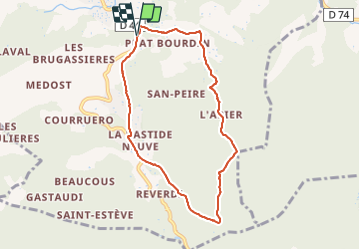
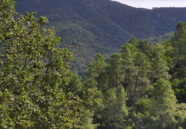
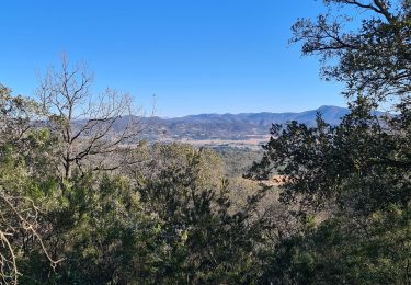
Trail Walking of 7.7 km to be discovered at Provence-Alpes-Côte d'Azur, Var, Le Plan-de-la-Tour. This trail is proposed by Chantheys.

Description

Départ sur la D44, depuis Le Plan de la Tour vers Grimaud.

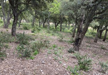
Au hameau de Coriolan, lorsque vous arrivez au bout du chemin asphalté, au cul de sac, empruntez face à vous le ravin d'un ancien ruisseau. Vous débouchez  de nouveau sur l'asphalte, entre deux entrées de propriétés privées.

Balade inspirée d'un tracé Visugpx.

Elevation profile

Photos

Positioning

Country:
France
Region :
Provence-Alpes-Côte d'Azur
Department/Province :
Var
Municipality :
Le Plan-de-la-Tour
Location:
Unknown
Start:(UTM)
301365 ; 4799940 (32T) N.

Comments

Please log in to post a review or rate the element


Trails nearby

Trail Mountain bike Grimaud - VTT de Port -Grimaud - Photo
Mountain bike
GUIDE
pascalou73

Mountain bike

Medium
Grimaud, Provence-Alpes-Côte d'Azur, Var, France
21 km | 26 km-effort
1h 45min
Yes
Trail Walking Le Plan-de-la-Tour - Plan de la Tour - Piste de colle Dure - Col de Vignon - Photo
Walking
LtZIP

Walking

Medium
Le Plan-de-la-Tour, Provence-Alpes-Côte d'Azur, Var, France
18.2 km | 25 km-effort
4h 16min
Yes
Trail Walking Le Plan-de-la-Tour - PLAN DE LA TOUR - AUTOUR DE SAN PEÏRE ET SAINT SEBASTIEN - Photo
Walking
jean-marie.parachini

Walking

Easy
Le Plan-de-la-Tour, Provence-Alpes-Côte d'Azur, Var, France
14.2 km | 18.8 km-effort
5h 4min
Yes
Trail Walking Grimaud - HAUTEURS DE BEAUVALLON - Photo
Walking
jean-marie.parachini

Walking

Easy
Grimaud, Provence-Alpes-Côte d'Azur, Var, France
6.1 km | 9.8 km-effort
2h 57min
Yes
Trail Walking La Garde-Freinet - Boucle la Mourre/ Cabrettes - Photo
Walking
LBarel

Walking

Easy
(1)
La Garde-Freinet, Provence-Alpes-Côte d'Azur, Var, France
9.8 km | 13.6 km-effort
2h 56min
Yes
Trail Mountain bike Sainte-Maxime - Beauvallon - Photo
Mountain bike
J2P

Mountain bike

Difficult
(1)
Sainte-Maxime, Provence-Alpes-Côte d'Azur, Var, France
30 km | 40 km-effort
1h 49min
No
Trail Walking Sainte-Maxime - 170121 mur - Photo
Walking
bebenoit83

Walking

Easy
(1)
Sainte-Maxime, Provence-Alpes-Côte d'Azur, Var, France
9.7 km | 13.5 km-effort
2h 20min
Yes
Trail Walking Le Plan-de-la-Tour - plan de la tour - Reverdi  les vernades - Photo
Walking
jean-marie.parachini

Walking

Medium
Le Plan-de-la-Tour, Provence-Alpes-Côte d'Azur, Var, France
8 km | 10.8 km-effort
2h 55min
Yes
Trail Walking Grimaud - Beauvallon. Plan de la tour et retour  - Photo
Walking
PIERRE ERIC INNOCENTI

Walking

Medium
Grimaud, Provence-Alpes-Côte d'Azur, Var, France
5.9 km | 8.4 km-effort
1h 55min
Yes


Close
My subscriptions